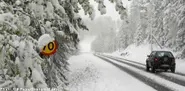
Temperatures are set to drop across Sweden next week, with the Swedish Meteorlogical and Hydrological Institute (SMHI) predicting as much as 20 centimetres of snow in some parts of the country.
Residents in some areas of northern Sweden woke up to white lawns this morning, as the first snow of the season outside the mountain areas started falling over Sweden on Thursday evening.
Falling temperatures are set to blanket much of Sweden with overnight frost in the coming days, according to forecasters, who add that residents shouldn't get their hopes up about a possible return of balmy summer weather.
Sweden’s weather agency has reported that this year’s summer was the worst in a dozen years, with the warm air avoiding the country with an “uncanny precision”.
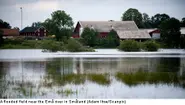
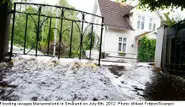
Heavy rainfall on Sunday night led to severe flooding in parts of Sweden, with experts predicting that after a brief warm spell on Monday, the wet weather will continue into the week.
Swedes were slightly shortchanged on summer this year, with Stockholm only enjoying six days of temperatures over 25 degrees Celsius, compared with 28 days in 2011.
As the long school holidays come to a close Swedish weather agency SMHI has forecast that the country is set to be divided in two, with a wintry chill in the north and tropical climes in the south.
After a summer which has hitherto offered up mostly rain, bad weather and flooding, the sunshine may be just around the corner, according to the latest weather forecasts.
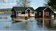
The situation has stabilized for flood-hit areas in south central Sweden as promising weather forecasts and receding flood waters have the area breathing a collective sigh of relief.
Emergency services in southern Sweden were concentrating their efforts on Tuesday evening on preserving "important societal functions" as flood-levels continue to rise.
More rain is set to fall on Tuesday on parts of Sweden already struggling to deal with flooding caused by weekend downpours that have left many rivers swollen and turned backyards into lakes.
Heavy rains caused flooding in parts of south central Sweden, prompting the country's weather agency to issue warnings Sunday night that a number of rivers may burst their banks.
Swedish forecasters have issued a warning for heavy rains across much of central and southern Sweden which is set to soak the country over the next 24 hours.
Heavy thunderstorms moving north through the country kept emergency services in Jönköping busy on Saturday night, while Stockholm can expect Class 1-warning extreme rains for most of Sunday.
Stockholm broke an 84-year-old cold record on Saturday, as the capital's temperature only reached 6 degrees Celsius, the lowest June maximum daily temperature the city has seen since 1928.
Three tornadoes swept by the coast of Halland, in south-western Sweden, on Saturday morning. The sight was “powerful but scary”, according to one surprised eye-witness.
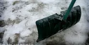
Residents in northern Sweden were forced to grab shovels rather than sun lotion on what was supposed to be the first day of summer, as much of the region was left covered in a thick blanket of snow on Friday.
Swedes were enjoying a real taste of summer heat on Friday with thermometers indicated record highs in some areas of the country, with more of the same promised over the weekend.
Water levels are rising rapidly in the Sangis river in Norrbotten, in northern Sweden, and meteorological institute SMHI has now issued their highest warning, Class 3, for the area.
Frost, cold and heavy snow falls surprised many on Saturday, but April showers are about to give way to warmer weather – with temperatures up to 20 degrees Celsius expected for the week ahead.
Heavy snowfalls in central Sweden have left swathes of the Stockholm area without electricity and caused major problems for public transport and road users on Saturday.